‘You can’t get the Metro to the MetroCentre’
Seems like an odd state of affairs when the MetroCentre, located in Gateshead, North East England is the second-largest shopping centre in the UK after Westfield London.
While rail served by MetroCentre station on the Tyne Valley Line, shouldn’t the MetroCentre (and more) be added to the Tyne and Wear Metro map?
Not only that, but the area surrounding the MetroCentre is surrounded by other major retailers such as Costco, IKEA and many more, as well as a large population in areas such as Whickham, Blaydon, Winlaton and more.
Partial Integration
While not ‘on the map’, partial integration already exists via the Network One ticket scheme, which covers the Northern operated route between Blaydon and Sunderland via MetroCentre, Dunston, Newcastle Central, Heworth and Sunderland.
These services originate outside of the Tyne and Wear area, with some beginning at Carlisle or Hexham, and running on to Morpeth and Nunthorpe via Hartlepool.
However, that still begs the question of why this connection isn’t shown on the Metro map? The world-famous ‘Tube Map’ of London shows a lot more than just the Tube lines; why shouldn’t the Tyne and Wear Metro map also show more than just the ‘Metro’?
Proposal
While it may be a slightly bold proposal; I would suggest that the time has come for a redrawing of the Tyne and Wear Metro Map to include routes such as Blaydon – Sunderland that are already included in ticketing schemes to make then much more prominent and visible to all.
This would help show the network as a cohesive whole rather than as a fragmented, ‘messy’ network where you not only have to change trains, but also tickets making it all seem disjointed and awkward; this being of most benefit to infrequent/non-users of public transport locally, as well as those visiting the region.
Proposed new for Metro maps as shown on transitmap.net are nothing new, and especially for the 2014 map, a LOT could be done overnight by inclusion of at least Blaydon – Sunderland route but my proposal would be (at least in short term)
This more or less directly draws from the London ‘Tube’ map; which is neither exclusively Tube lines (i.e. London Overground, DLR, Thameslink, and even a cable car!) with also 16 stations also classed as outside of London proper with eight on the Metropolitan and Central lines. In addition, five (Amersham, Chalfont & Latimer, Chesham, and Chorleywood on the Metropolitan line, and Epping on the Central line) are outside of the M25.
Therefore, there should be very few reasons (excuses) as why Tyne & Wear Metro map must be restricted to just the Yellow and Green routes, and those operated solely by the current Class 599 Metrocar or the soon to come Class 555 Metro’s from Stadler.
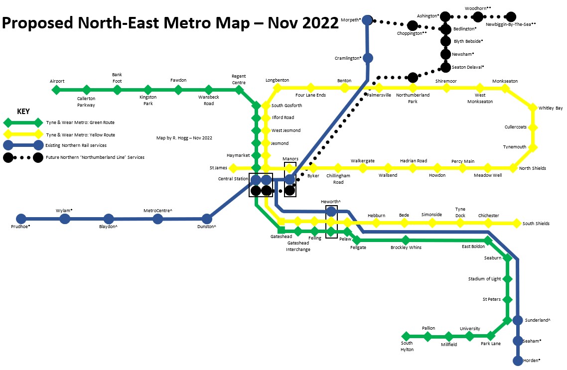
Yellow Line (St. James – South Shields) Existing Metro service, unchanged from present.
Green Line (Airport – South Hylton) Existing Metro service, unchanged from present.
Blue Line (Blaydon – Sunderland OR Prudhoe – Seaham/Horden) Existing Northern service, added to map (colour reflects following River Tyne and Durham Coast), extension to Prudhoe, Seaham/Horden to give wider coverage of large towns on edge of Newcastle/Gateshead/Sunderland.
Branch of Blue Line (Newcastle – Morpeth) Existing Northern service, added to Network One or similar ticketing arrangement and again added to map to again expand network beyond Tyne and Wear, inclusion of Morpeth would also bring Cramlington (2nd largest town in Northumberland) into fold. Might be simpler to add as Blue line as current services are Morpeth – Carlisle typically and would therefore serve MetroCentre, Blaydon etc.
Black Line (Ashington – Newcastle (Northumberland Line) and possibly future route to Washington/South Hylton if ran as through route) Future Northern service, with work progressing at time of writing (Nov 2022), again added to or similar arrangement to Network One ticketing system and added to Tyne and Wear Metro Map. Black reflecting heritage of the Northumberland Line for carrying mostly coal over its long history. Services could in time be expanded to Newbiggin-By-The-Sea, Lynemouth and onto Butterwell Line.

While such additions may be more complex to arrange behind the scenes, putting the above routes (and maybe more in future) onto the Tyne & Wear Metro network and adding appropriate branding at stations could certainly go a long way to making public transport much more visible and cohesive across the North East.
Not only that, but places such as Ashington and (perhaps with relocation or secondary bus station) Morpeth are ideal locations for interchange with buses serving the rural communities to north and west of the denser urban area around Newcastle.
In my view, making this relatively simple change and that the Metro network perhaps should extend beyond the reach of the Metrocar would radically help making Public Transport more visible and user friendly in the North East, as clear pricing and more routes make the system much more useful and should help drive modal shift toward sustainable transport.
Going back to the comparison of Westfield London; it is served by Wood Lane Station on the Circle/Hammersmith and City Lines, Shepherd’s Bush on the Central Line, as well as Shepherd’s Bush railway station on the London Overground/Southern Network.
Surely asking for the MetroCentre to be on the Tyne & Wear Metro Map is a modest ask?
Please add any comments below:
