Disclaimer: The following is my own thoughts on the future beyond the ‘Northumberland Line‘ scheme; they do not represent the views of anyone else or any other bodies. This is also very much a outline idea without any firm costings or access to surveys etc.
Newcastle to Ashington
This is the current proposal and construction well underway to achieve trains running from Newcastle-Upon-Tyne to Ashington, Northumberland; calling also at Bedlington, Blyth Bebside, Newsham (also for Blyth), Seaton Delaval and Northumberland Park [maybe also Manors?].
This is a great prospect and due to open in 2023/4 with a half hourly peak time service and hourly off peak, and a brilliant 35min estimated running time from Ashington to Central Station, very competitive with buses which take around 63mins to complete the same journey, and only marginally slower than a car trip, but without the stress and costs of parking as well as being a much more environmentally friendly mode of transport.
Ashington to Newbiggin via Woodhorn
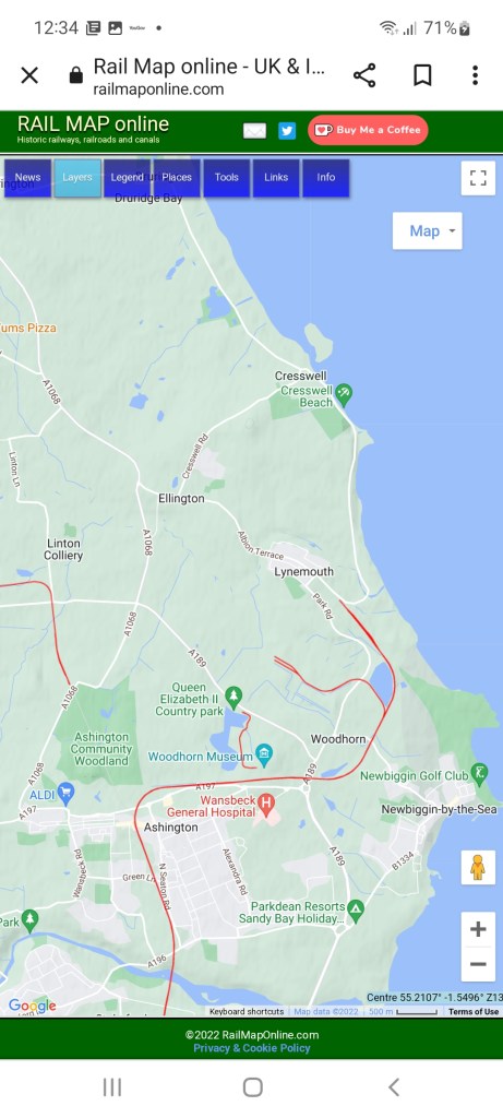
This is very much seen as the next step north from Ashington, with the route as far as Woodhorn being part of an existing double tracked freight route serving Lynemouth Power Station, with the long disused but mostly complete branch to Newbiggin diverging near the A189 underbridge towards the town. See more here.
Again this proposal is welcomed and Woodhorn in particular will serve a very large area of eastern Ashington as well as the popular Woodhorn Museum.
Ashington to Lynemouth via Woodhorn
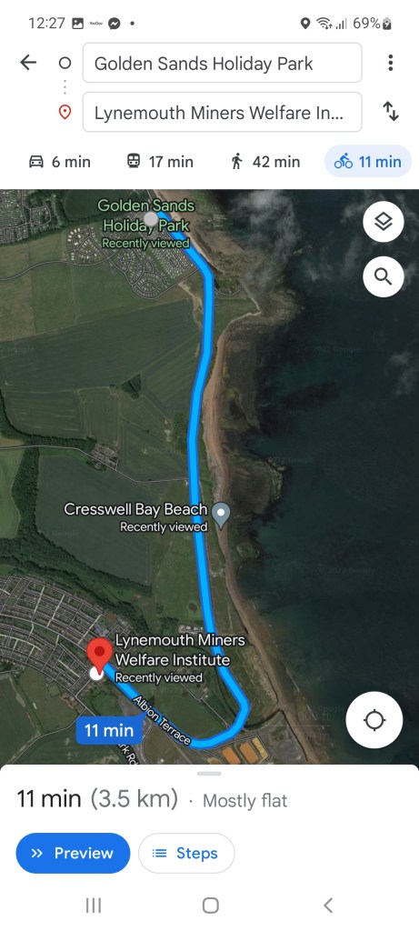
As far as I’m aware, this proposal has not been raised before, but, as it stands, the current headshunt for biomass services to/from Lynemouth Power Station is only c.400m short of the edge of Lynemouth village near to the Lynemouth Miners Welfare Institute (NE61 5YJ).
Lynemouth (population 1858 in 2011) is the neighbour to the larger Ellington (population 2778 in 2011) giving a combined population of 4,636 based on these 2011 figures.
Since 2011, there has been further housing development, particularly in Ellington which would suggest that the population will have grown beyond this figure (to be confirmed by 2021 census data).
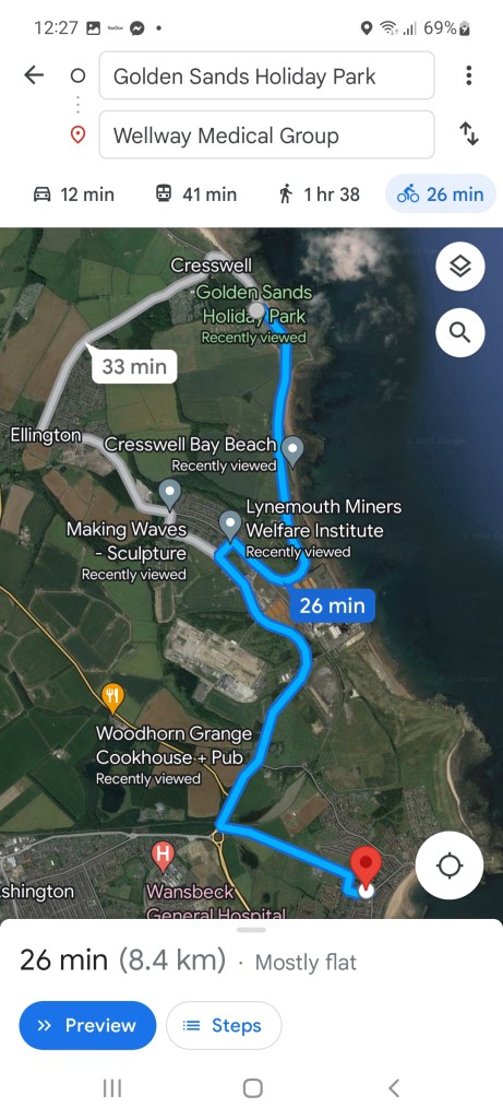
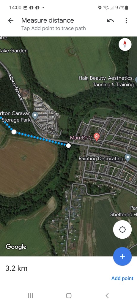
The site at Lynemouth is also very close to to the picturesque Northumberland Coast starting from Cresswell (Golden Sands Holiday Park) then running up through Druridge Bay towards Amble. By foot/bicycle, this is a 15km (9.3 miles) mostly flat route as shown below.
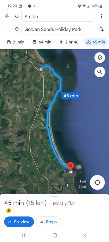
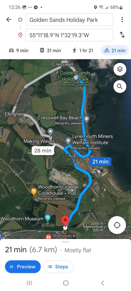
The distance from the proposed staton at Lynemouth (adjacent to Lynemouth Miners Welfare Institute) to Golden Sands is a mere 3.5km (2.2 miles), compared to a likely 6.7km (4.2 miles) from the propised Woodhorn station and 8.4km (5.2 miles) from Wellway Medical Group (near former Newbiggin by the Sea station).
So while Ellington and Lynemouth, even combined is a reasonably small population centre, the opportunity afforded by a working freight route lying so close to the settlements, combined with the opportunity for much more sustainable tourism to this section of the Northumberland Coast is surely too good an opportunity to miss?
In addition, assuming that Woodhorn Station is west of the point where the Newbiggin branch will diverge, any services running up to Lynemouth would increase service frequency through Woodhorn, Ashington and any other stations dependent upon where the service runs through to.
Lynemouth to Widdrington & Beyond
A bolder plan would be to reinstate the old mineral line route through Lynemouth, past Ellington and to connect on to the Butterwell Line near Linton Colliery before connecting northwards onto the ECML. This route was closed as a through route in approx 1968 when changes to coal extraction from the former Ellington and Lynemouth collieries rendered the line surplus (coal being brought out via the Bewick Drift directly to Lynemouth Power Station when it was a coal plant).

The map above shows the overall route proposed, largely running on former alignment, but would require a new direct east-west link at Linton Colliery to join the ECML.
Ashington to Alnmouth
The proposals for Ashington to Alnmouth have been long standing and while the route via Butterwell has fewer obstacles than the Lynemouth Link proposed above, it might prove preferential to have BOTH links in the longer term.
Lyne Junction
A new junction connecting east to north (Butterwell Line to ECML) in the vicinity of the River Lyne (south of Widdrington) would certainly be needed due to the lack of one headed north currently.
This would likely take the form of a grade-separated junction as seen at Northallerton, which avoids ‘conflicting moves’ of trains crossing the path of an oncoming one, much like the junction of the nearby A1/A697 allows road vehicles to diverge or merge into a stream of traffic headed the same way but not cutting across the path of oncoming traffic.
Under any proposal, it would likely be that this form of junction would be required, so making best use of it would certainly be advantageous.
Lyne Junction to Linton Colliery
Again, the proposal would share common track with the route between the new junction with the ECML and the route as far as Linton Colliery, with the proposed Butterwell route to Ashington turning south here, but the link to Lynemouth would continue broadly eastwards.
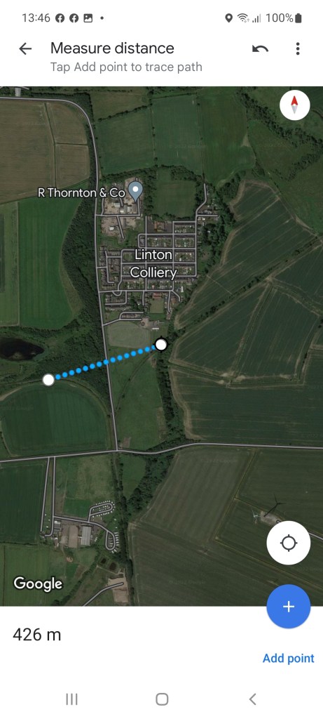
Passing Linton Colliery
A new alignment east to west just to the south of Linton Colliery would be needed, this would likely require the road to either be raised or lowered to pass over or under the new railway, but such a link would likely be less than 500m in length overall to join both existing alignments here (see image below).
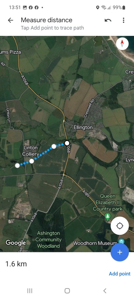
Linton Colliery to Ellington (A1068)
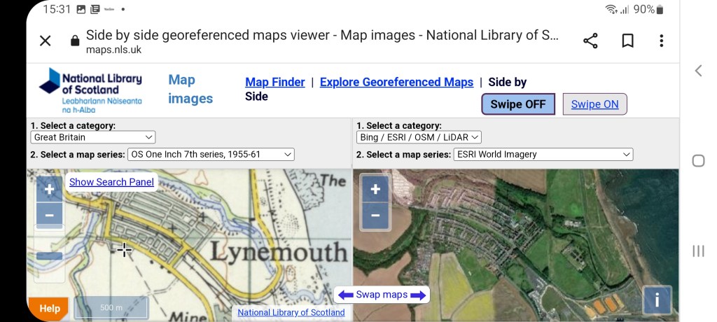
Arguably the most complex section is reconnecting through Lynemouth itself. This section was originally partially in a cutting at its eastern end, passing beneath Bridge Street, with Fenham Road at the western end also being a bridge over railway, but at greater height. The map below from the National Library of Scotland shows the old arrangement.
The formation between Linton Colliery and the edge of Ellington (west side of A1068) is broadly complete, although the embankment nearest the A1068 has recently suffered from an underground fire and likely would require rebuilding. From the junction with Butterwell Line to the western edge of A1068 is 1.6km (1 mile).
Interestingly, this route has passenger carrying precedence with passenger services operated by the Ashington Coal Company and NCB using industrial steam locomotives and ex-mainline wooden carriages until 1966 (outlasting British Rail services to Ashington) running to a platform within the yard of Ellington Colliery.
Ellington A1068 to River Lyne
This stretch of the A1068 bypassing Ellington was built after the closure of the route, with stretch of embankment and the bridge over Ashington Road being removed likely around the same time. While this would mean two bridges and rebuilding the embankment, it is approximately only about 100m in overall length and not too dissimilar to the challenges faced by the Great Central Reunification project which is being undertaken to join two heritage lines in a much more complex urban setting.
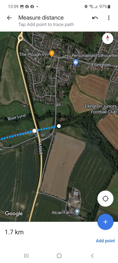
Beyond Ashington Road, the route is again mostly intact, and repurposed as a footpath for large sections as far as the River Lyne and western edge of Lynemouth. This takes the route to a mere 3.2km in length (2 miles).
Through Lynemouth
The most challenging section would be the stretch through Lynemouth itself; the route formerly running partially in a cutting, with Fenham Road crossing the line at height via a bridge. The map below from National Library of Scotland showing this arrangement.
It would likely be best to try and rebuild to near this original design; it avoids level crossings (particularly difficult to be approved for new installations) and separation also gives simplicity, avoiding the signalling requirements for level crossings and finally is a generally safer way to build and operate a railway.
Advantages for Ellington, Lynemouth and Woodhorn
By having the route via the coast as a through route, rather than as a second branch radiating from Ashington, it means that passenger services would call at these destinations en-route, rather than a change at Ashington if travelling via Butterwell heading to/from the north.
Lynefield Park (former Alcan aluminium smelter) and Lynemouth Power Station could be and are respectively generators of railfreight; the former home to some major manufacturers of heavy pre-cast concrete sections which could be shipped by rail. While Lynemouth Power Station may have a finite lifespan (it is already quite an aged power station), the site may find re-use for either power generation or other industrial use in future, placing it again on a through route avoids ‘backtracking’ to turn trains around to head northwards.
Also, if both routes approach was taken (Butterwell and Lynemouth routes), then through freight and some semi-fast passenger services could be run via Butterwell, in the case of the latter perhaps making key stops such as Ashington & Blyth as opposed to running via Morpeth. The longer route would then have more capacity to deal with all station stopping services, particularly if sections west of Lynemouth were single tracked (particularly the cutting through Lynemouth).
Conclusion
In my own view, at a minimum a station serving Lynemouth near to the Miner’s Welfare should be provided, and services either being hourly (splitting half hourly service at Ashington into hourly Newbiggin and Lynemouth), or, perhaps preferentially, having paired sets working as far as Woodhorn and trains physically split, one portion to Newbiggin, the other to Lynemouth then recombining at Woodhorn.
While a through route via Lynemouth would present challenges, I believe it has big potential advantages, especially for Woodhorn (and indeed Newbiggin) of placing stations on a through route rather than a branch from Ashington.

One thought on “The Ellington & Lynemouth Link”